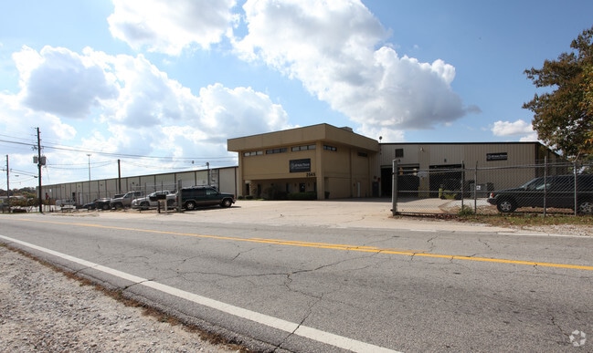
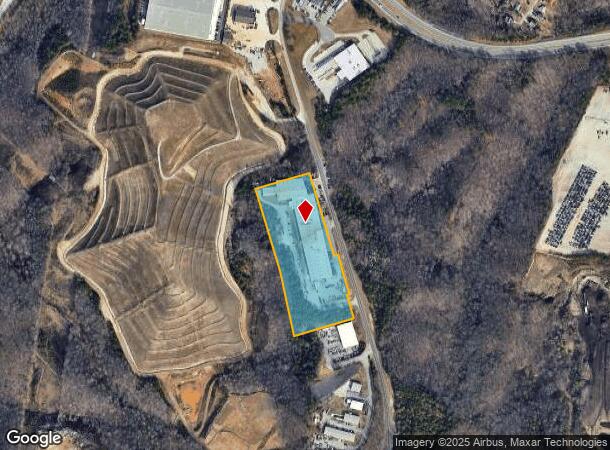
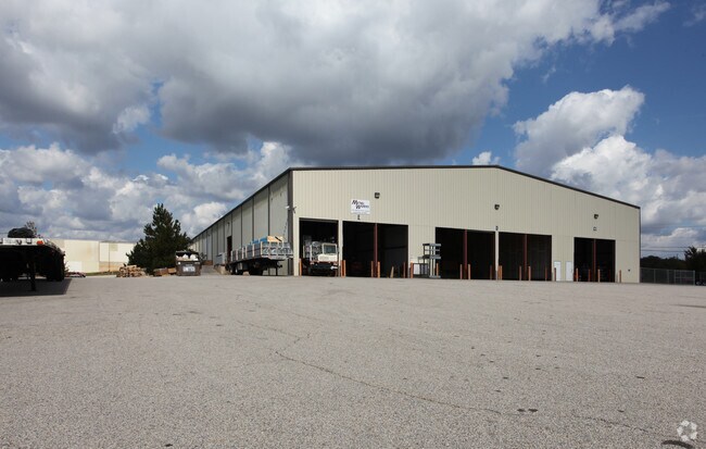
Property Record
2545 Monroe Dr, Gainesville, GA 30507
NEARBY LISTINGS FOR SALE OR LEASE
Property Detail
2545 Monroe Dr
15-00032-00-017
24 MONROE DRIVE
Officebuilding
Hall
X
Georgia
13139C0195H
8.94 AC
2025
I-985/Gainesville
2025
Atlanta
001204
Gainesville, GA
3,440 SF
DEMOGRAPHICS near 2545 Monroe Dr
1 Mile
3 Mile
5 Mile
2024 Total Population
3,616
29,059
73,953
2029 Population
3,987
32,013
81,592
Pop Growth 2024-2029
+ 10.26%
+ 10.17%
+ 10.33%
Average Age
33
33
35
2024 Total Households
1,034
8,802
24,051
HH Growth 2024-2029
+ 10.06%
+ 10.10%
+ 10.27%
Median Household Inc
$38,691
$46,084
$54,438
Avg Household Size
3.20
3.00
2.90
2024 Avg HH Vehicles
2.00
2.00
2.00
Median Home Value
$137,713
$171,779
$228,553
Median Year Built
1990
1984
1990
Nearby Places
Map Layers
Map Styles
 Street
 Aerial
- Restaurants
- Banks
- Shops
- Fitness
- Groceries
PUBLIC TRANSPORTATION
COMMUTER RAIL
Gainesville Amtrak Station (Crescent - Amtrak)
DRIVE
WALK
Distance
Gainesville Amtrak Station (Crescent - Amtrak)
4 min
2.1 mi
Freight Ports
Georgia Ports - Savannah
DRIVE
WALK
Distance
Georgia Ports - Savannah
314 min
249.5 mi
SALE & LEASE HISTORY
LISTING DATE
SALE/LEASE

Sep 24, 2016
For Lease
May 30, 2018
For Lease
Mar 10, 2017
For Lease
Jul 26, 2019
For Lease
Nearby Properties
Address
Land Use
TOTAL SIZE
Lot Size
Zoning
Address
Land Use
TOTAL SIZE
Lot Size
Zoning
564,132 SF
48.45 AC
PUD
Address
Land Use
TOTAL SIZE
Lot Size
Zoning
578,645 SF
110.18 AC
PUD
Address
Land Use
TOTAL SIZE
Lot Size
Zoning
334,800 SF
56.96 AC
PUD
Address
Land Use
TOTAL SIZE
Lot Size
Zoning
39,637 SF
31.55 AC
R-II
Address
Land Use
TOTAL SIZE
Lot Size
Zoning
27,221 SF
2.23 AC
G-B
Address
Land Use
TOTAL SIZE
Lot Size
Zoning
2,160 SF
5.60 AC
PUD
Address
Land Use
TOTAL SIZE
Lot Size
Zoning
44,052 SF
19.19 AC
PUD
Address
Land Use
TOTAL SIZE
Lot Size
Zoning
58,020 SF
3.15 AC
PUD
Address
Land Use
TOTAL SIZE
Lot Size
Zoning
3,284 SF
28.53 AC
PUD
Address
Land Use
TOTAL SIZE
Lot Size
Zoning
100,864 SF
4.10 AC
PUD
Address
Land Use
TOTAL SIZE
Lot Size
Zoning
77,333 SF
11.74 AC
PUD
Address
Land Use
TOTAL SIZE
Lot Size
Zoning
54,751 SF
33.38 AC
AR-1
Address
Land Use
TOTAL SIZE
Lot Size
Zoning
76,726 SF
0.42 AC
C-B
Address
Land Use
TOTAL SIZE
Lot Size
Zoning
469,180 SF
25.56 AC
H-I
Address
Land Use
TOTAL SIZE
Lot Size
Zoning
46,795 SF
17.38 AC
PUD
Address
Land Use
TOTAL SIZE
Lot Size
Zoning
102,317 SF
6.90 AC
PUD
Address
Land Use
TOTAL SIZE
Lot Size
Zoning
11,430 SF
38 AC
R-I
Address
Land Use
TOTAL SIZE
Lot Size
Zoning
258,372 SF
24.38 AC
L-I
Address
Land Use
TOTAL SIZE
Lot Size
Zoning
148,619 SF
30.75 AC
O-I
Address
Land Use
TOTAL SIZE
Lot Size
Zoning
88,042 SF
280.24 AC
PID
Address
Land Use
TOTAL SIZE
Lot Size
Zoning
1,191 SF
262.63 AC
H-I
Address
Land Use
TOTAL SIZE
Lot Size
Zoning
1,441 SF
10.46 AC
PUD
Address
Land Use
TOTAL SIZE
Lot Size
Zoning
304,088 SF
17.45 AC
H-I
Address
Land Use
TOTAL SIZE
Lot Size
Zoning
140,805 SF
3.74 AC
PUD
Address
Land Use
TOTAL SIZE
Lot Size
Zoning
4,032 SF
89.43 AC
R-I
Address
Land Use
TOTAL SIZE
Lot Size
Zoning
63,571 SF
31.97 AC
PUD
Address
Land Use
TOTAL SIZE
Lot Size
Zoning
82,610 SF
13.68 AC
G-B
Address
Land Use
TOTAL SIZE
Lot Size
Zoning
60,062 SF
0.51 AC
C-B
Address
Land Use
TOTAL SIZE
Lot Size
Zoning
67,383 SF
1.68 AC
C-B
Address
Land Use
TOTAL SIZE
Lot Size
Zoning
301,380 SF
16.76 AC
I-1
The World's #1 Commercial Real Estate Marketplace
Connect with us
© 2026 CoStar Group
The information above has been obtained from sources believed reliable. While we do not doubt its accuracy we have not verified it and make no guarantee, warranty or representation about it. It is your responsibility to independently confirm its accuracy and completeness. Any projections, opinions, assumptions, or estimates used are for example only and do not represent the current or future performance of the property. The value of this transaction to you depends on tax and other factors which should be evaluated by your tax, financial, and legal advisors. You and your advisors should conduct a careful, independent investigation of the property to determine to your satisfaction the suitability of the property for your needs.